Yesterday I paddled out to the largest island in the St. Louis River estuary, which some refer to as being the largest freshwater estuary in the world. It just might be. If you peer off into the distance of the aerial shot below, you can see the very head of the Great Lakes, Superior, the largest lake in the world. The line of demarcation between these two great bodies of water is that spit of land between them, just below the horizon line. That is the largest freshwater sandbar in the country. The attention and gaze of tourists and locals alike has tended to focus exclusively on the other side of that dividing line. I have only recently caught on to the immense depth of cultural, historical, aesthetic, and environmental richness that lies in and along this amazing river. My introduction to it came by riding the Lake Superior & Mississippi Railroad last Fall, after which I wrote a column in support of saving the railroad for future generations. You can read that piece here. As far as I know, the future of the train continues to hang in the balance (albeit postponed for another year). This ride was instrumental for me in gaining an appreciation for both the river and also of this often overlooked portion of the city. Among many incredible tidbits previously unknown to me, I was introduced to Whiteside Island for the first time.
Right here, on this enormous island, a millionaire built a large vacation home and an impressive farm that may have been the largest in the area. During WW I, for example, they harvested 3,500 bushels of wheat in a season. They kept pigs, trained numerous racing horses, tended a herd of black angus cows, kept 40 brown swiss milking cows at one time, had 500 sheep, cared for an enormous vegetable garden (all with the help of hired hands), and much much more. Below you can see the basic outline of the former pasture and fields, slowly being swallowed up by forest. I’ve been dying to see what remains of the old place, and got out there just as soon as prudence would allow (about a week after ice-out, earlier than ever this year). Arriving so early spared me the nuisance of ticks and the concealing effect of what otherwise would have been an unpleasant tangle of grass, brambles, and bushes.

It is listed as Clough Island on maps for the original owner, Judge Solon Clough. He sold it to Robert Whiteside in 1904. Since the Whiteside family worked it for so long, and owned it for nearly a century, a more proper name for it is Whiteside Island.
From his obituary in the Skillings Mining Review in September of 1931, “Mr. Whiteside was unquestionably the greatest lone hunter for mineral, timber, and oil this country has ever produced.” He was a baron—a force to be reckoned with—in each of these industries. They say Duluth had more millionaires per capita than any other city in the world during the early part of the 20th century. Mr. Whiteside was especially prominent even among them.
My knowledge and enthusiasm for this subject can be traced entirely to a delightful 70-page book, by Claire Schumacher, called The Whiteside Island Story. Yesterday, the same day as my voyage, I looked her up and was stunned to discover that she is still alive and as sharp as ever at 88 years young. I arrived at her modest home in a trailer park in Proctor shortly before her home health aide finished her shift. I may have been just as excited to meet Claire in person as to have finally gotten out to the island. She really is a cultural treasure. During our visit, I obtained a copy of the self-published book directly from her hand. It cost me a whopping $15, and it’s worth every penny. I have already checked the book out twice from the library, and am ecstatic to possess a copy of my own.

It turns out that Schumacher has written numerous little books, and even some larger ones. Her first, Codyview: Buffalo Bill’s Link With Duluth, was written in 1969, and amounts to little more than a pamphlet. She sold 1,000 copies of that work over the course of a single week of festivities celebrating the city of Proctor’s diamond jubilee. Buffalo Bill owned a home in Proctor, a neighboring city, and she paid a group of boys 25 cents for each copy they sold. At $1 per each they sold like hotcakes and the kids made a pretty penny. Claire even had to order another print run. She was self-publishing work after painstaking work long before it was cool, and lacked all of the conveniences that modern self-published authors like myself take for granted. I chuckled while exclaiming that she sold nearly twice as many copies in that one week without the aid of the Internet as I have in an entire year. She continues to distribute her books herself, and insisted that I provide you with her direct phone number. You can reach Claire Schumacher yourself at 218-624-7728. Be sure to regularly read local authors. Your love and sense of curiosity for your corner of the world will increase exponentially as a result.
I commented that people must have thought she was a bit crazy and eccentric to be researching and writing so many books, having them printed through the local downtown printer, Paper Hog, and then distributing them herself. Then I asked if her husband was supportive of her writing. “No, he was not… But he was supportive of The Whiteside Island Story.” It remains her best selling book. There is a very rudimentary author’s page featuring her on Amazon, which you can see here. It hasn’t been updated in ages, however, and not everything is available on there.
These days she is unable to read independently, due to failing eyesight. This bugs her to no end. She was thrilled when I offered to trade her a copy of my audiobook in exchange for one of her other books. Claire says she bugs people to read to her whenever she can. As a fellow author, I was inspired by her natural storytelling ability, and by her fortitude and persistence in the craft of writing. I could have stayed for hours. Knowing I’d need every minute of remaining daylight, I had to cut the visit short. Tell me this isn’t awesome, though…

She always dates her autographs, and by a happy coincidence this is the same date I made the trip out to her island (it really is nearly as much hers as that of the Whiteside’s). A couple hours later, while stomping around the island with this in hand as a guide, I dropped it into a mud puddle. The genuine Whiteside stains paired with the signature have rendered this booklet priceless to me.
Joining me on this trip is a guy who reached out to me once to say he appreciated my newspaper column. Knowing Mike lived in the area, I was ecstatic to learn that not only did he own a pair of kayaks, he was happy to take the trip with me. Here you can see he lives across the street from the old Work People’s College, which dates to 1907 (the same era that the Whitesides were developing the island), and was run by the Finnish Socialist Federation. It was a radical labor college, and seems pretty doggone interesting.
 The boat launch is close by, only hundreds of feet away. I marvel at the recreational opportunities that abound on Duluth’s west end. They have the river, the Munger trail, and the Superior Hiking Trail sits just six blocks up the hill.
We crossed some big water to get out there, under the watchful eyes of a bald eagle. That eagle’s nest in the background is enormous. Perhaps the largest I’ve ever seen, though it looks like a little speck in the center of this photo…

I was rather stunned to learn that nearly all the islands, even the ones closest to the Minnesota shore, are considered as part of Wisconsin. The fellow pictured above has duck hunted out on the river, literally less than a quarter-mile from his front door, but had to obtain an out-of-state hunting license from the neighboring state of Wisconsin. I would find that difficult to swallow, because many of these areas are more heavily used by Minnesotans. The Wisconsin border comes so close to Minnesota, in fact, that it even clips the Spirit Lake Marina (located in the Riverside neighborhood). The marina’s owner is required to file property taxes in both states as a result. This is all owing to the fact that Wisconsin attained statehood 10 years prior to Minnesota (1848 vs 1858), so they essentially had dibs.
Arriving at the southeast corner of the island you find the following sign, which the Nature Conservancy erected after purchasing the island for conservation purposes several years ago. It marks the best landing spot. Claire provided the photos you see here of the house and barn in their former glory. She obtained these pictures directly from the Whiteside family, and her knowledge of the island was likewise obtained by doggedly pursuing firsthand sources like Mr. Whiteside’s son, and the caretaker who lived on the island for 25 years (until the home burned down in 1956). The caretaker’s wife lamented the loss of over 1,000 quarts of canned goods to the fire when she spoke to Claire more than 15 years after the incident…

As you crest the rise of the bluff from the landing spot, you will find the ruins of the house first, on your right. A concrete sidewalk formerly connected all the structures, but has since been overtaken by encroaching wilderness. I took this picture while standing inside the former basement, out of which grow numerous trees. This was formerly a very nice home with fine woodwork. Mr. Whiteside insisted on using only the highest quality lumber from his own lumber mills, and even had an entire load of wood that had been ferried over on a barge sent back when it didn’t meet his exacting standards. It was fully plumbed, and they even had electricity, which arrived through a copper cable that had been extended all the way from the mainland. During the Great Depression this cable was cut and stolen.

I was stoked to be wearing clothing authentic to the era, comfortably nestled in wool from head to toe. Lacking spray skirts on the kayaks, this was important for feeling warm and cozy. If you look closely, however, you will see the feminine Bogs boots I borrowed from Mikey’s wife, which came complete with daintily painted flowers in pink and purple. These really may have salvaged the entire experience of the soggy island!

Here’s some ruffed grouse droppings on the foundation of the nearby pump house…

You can still see the pipe in the background here, which marks the site of the original well. Ironically, being surrounded by so much water all around the island, they reportedly had to drill down 600 feet to reach the aquifer.

Here is where the water was then piped into the basement of the big house nearby. You have to look closely, but you can make out the corroded pipe just right-of-center near the bottom here…

From there you can follow the trail to the former barn. If you go back to the original photo above you can catch a glimpse of the massively sized L-shaped barn! It was reputed as being the largest around. After walking the outline of the foundation, I believe it. It was essentially the size of two giant barns glued together as an L.

You can follow the foundation around the entire former structure. Its enormity defies belief.
 Interestingly, red osier dogwood marks the outer limits of much of the former structure. It’s difficult to really get a sense of its size in this photo, but I was fascinated with how the dogwood basically serves as a marker (center, left, and then right down the L). Could they have planted it there?

The former pasture and fields go on forever! We walked quite a distance to get a sense of their former grandeur.
 The Nature Conservancy lists the island at 358 acres, but the original abstract specifies 515. I dunno. It’s huge. After trudging around in quite a bit of standing water, we headed down to the picnic table for some treats.
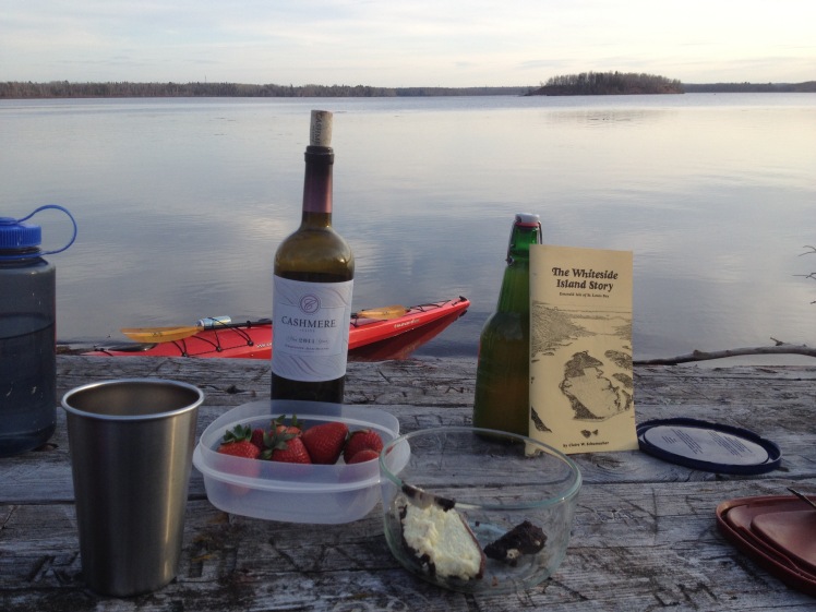 You guessed it. In the foreground sits the last remaining morsels of the best cheesecake on the planet (made from scratch by a friend), so you can give up on your search for it. That, along with the wine, was left over from our family’s Easter celebration. I was happy to share these with my friend who generously shared his entire fleet of kayaks and came along on the journey. This really is a primetime spot for a picnic. Reluctantly we shoved off only because the sun was setting. For being so close to the city, it was remarkably clean and well taken care of. On this particular day we were sitting on the leeward side of the island, completely sheltered from the wind.
Though nightfall rapidly approached, we paddled around the entire island, mesmerized. It definitely feels removed and unto itself, but the pulse of the city can be seen and heard nearby. Trains and freeway noise provided a steady drone. High atop the hill in Minnesota we could see the freeway as we paddled around the northern end of the island, and eventually I could make out the McDonalds sign way up there at Duluth’s boundary with Proctor. The city was in its proper place, and never felt unwelcome or seemed to be a distraction in any way. If anything, it served to heighten the sense that it was a tremendous treat to be lavished with such bounty so near to civilization. Just to the right of the ski hill is a small saddle between the hills, and the McDonalds sign rests above the next rise. You probably won’t be able to make it out there…

The north side of the island faces most of the city and industry, while the southern portion has a wilder feel. Here, to the north, you can see three large piles of black taconite in the distance (processed iron ore) near the bridge that connects Minnesota to Wisconsin.

There was more wildlife in, on, and around the river, than any other single place I’ve ever explored in these parts. Waterfowl was evident in all directions. Dozens of pairs of nesting geese, on the cusp of rearing families, kept watchful eyes on us as we passed through their territory, and there were numerous ducks. We also passed by two or three active beaver lodges, and I saw four beavers. Two of them were so close that I could smell them, which I’ll describe as a sort of musky scent. I’ve never actually smelled a beaver before, so I appreciated the pungent awakening of my olfactory system. Incidentally, the sacs near the anal glands of beavers secrete a sought-after goo called castoreum, which they use to mark their territory. Perhaps, being Spring, they produce more than usual? Food manufacturers sometimes use the excretion, obtained through a process called “milking,” for creating vanilla flavoring. The ingredient list will sometimes refer to their use of castoreum as simply, “natural flavoring.” Interesting, no? They didn’t smell like vanilla last night at any rate, but the aroma wasn’t altogether unpleasant either.
We paddled near a factory that makes the sweetener used in Jolly Rancher candies. I’m pretty sure they don’t milk any beavers below their plant, however.
There was a ton of beaver activity between Tallas Island and the Minnesota mainland. As close as Tallas is to our shore, it is still considered part of Wisconsin. It was getting dark, but it might be as close as 50 feet from shore, so this surprised me. It’s gorgeous at any rate.
At one point we had to do a somewhat perilous crossing of some stubborn ice:

It was only after I re-entered the kayak that I realized an urgent need existed to relieve myself. Later, as we glided alongside the previously mentioned marina, this became an emergency. Though we were just five minutes from our boat landing at Clyde Ave, I stormed the marina as if I was part of an amphibious assault. Risking a fall into the icy water, I launched out of the kayak as if my life depended upon it, and hoisted the entire boat onto a wooden platform to prevent it from floating away. Due to all the fumbling around, I wound up wetting my pants for the first time in at least 20 years. Dare I say it, there has never been a time in my life when it was more worth it.
By the time we reached the Clyde Avenue boat landing, all natural light had been extinguished. The lone streetlight marking the launch was a welcome beacon. What an adventure!
I adore the sense of place that permeates the river. This dates back centuries for the Native American community. I pointed out a house on a very handsome point with a commanding view of Whiteside Island, and all points south. My friend casually mentioned, “Oh yeah, that was Willard Munger’s (referring to the longest serving member of the Minnesota House of Reps at 42 years) house. He built it.”
Approaching the marina, I learned that it was formerly a shipyard. Many of the U.S. Navy’s ships from WWII came out of here. Mike remarked that his wife’s grandfather, William Loftin, was killed in this very shipyard at the age of 47. He was a foreman leading a crew atop a high platform when something fell. He was able to get his entire crew to safety, but he died when a steel plate hit him in the head. His daughter, mother to this woman who now lives just a stone’s throw down the road, christened the ship. It’s a sad story, indeed, but I appreciate the evidence of community roots. I’ve never lived in a place where any other family members lived and died, and strongly desire to sink down such roots for my children right here. Stories of place (of people, economic entities, wildlife, culture, and the land itself) seem to tumble out of Mike’s mouth at every turn. This is where he grew up. These are the people, for better or for worse, who have surrounded and shaped him. This is the landscape that has inspired him. And now, me. By simply transmitting this story to you, I’ve become a part of it, and so have you. This excites me, because stories are powerful. Like rivers, they are vibrant. Ever changing. Never static.
I’m submitting this story to the One River, Many Stories project. It took me a while to understand the point of this endeavor to encourage journalists, storytellers, and artists across all mediums to turn their attention toward this topic of the St. Louis River. I poured a lot of myself into understanding, and into actually entering this one little portion of the Story. Without a sense of place, there is no story. Without a story, there is no sense of place. Wherever you live, I urge you to enter into that story. Delight in sharing it with others. Become part of it. Help to shape it as even now the story is being passed along to the next generation. It’s always in motion. Rather than fight the current, perhaps use it to help shape the contours of a narrative continually in the process of being written, even at this very moment…


You’ve done it again, Eddy. Great stuff, from Claire to the beavers to your “emergency.” It’s a winding river of reading goodness.
Thanks so much, Mark. I appreciate you reading all the way through this rambling thing. Eventually I’ll have to learn how to break such stories up into much shorter vignettes. Until then, keep adventuring and storytelling…
Hi Eddy — Great story! Imagine that, someone actually getting out onto the river to write about it. I commend you. And you talked to Claire!
Did you know that Clough was once slated for a condo/golf course development? Your experience there with wildlife underscores the environmental importance of the island, and one of the reasons the development didn’t go through. Here’s a story link for more info: http://uwiscseagrant.tumblr.com/post/132222876587/dorothy-anway-clough-island-conservationist
I have one correction to offer you. MN and WI points are not the longest freshwater sandbar in the world. That’s a local myth. There are ones that are larger or just as large in Canada and Russia. It is safe to say it is “one of the largest” freshwater sandbars in the world, however. I can send you the specifics if you need them.
Hey Marie! Thanks for kudos and commendation. I wanted to mention that crazy golf course/condo thing, but felt it was too long as it was. For me the best part of how this fell through is to look at the very last lines of Claire’s book. Her final time out to the island was in 2002, and she met some sort of surveyor out there or something. The news of the development broke her heart. She writes in addendum at the time, “(The island) was about to be desecrated. I could only hope the plan would fall through.” How gratifying it must be for her to have lived up to this time to see that the plans did ultimately fall through!
Regarding the other part, shucks! Perhaps we could have an argument some time or an arm wrestling match. Everything I’ve seen online from reputable sources indicates the MN and WI points add up to the longest, and the Internet is 100% reliable. Isn’t it???? I’m open to the possibility that it’s the longest in the U.S., and will go ahead and remain blissfully ignorant for the time being….
Hi again Eddy. Yeah, I figured you must have come across the Clough Island development plans along the way somewhere. That’s cool about the ending of Claire’s book. And you would be right in saying that MN & WI Points are the longest in the U.S. But allow me to roll up my sleeve and arm wrestle. I spent a lot of time in 2014 researching the “longest in the world claim,” for a report for the U.S. Army Corps of Engineers. I contacted scientists at UMD’s Large Lakes Observatory and, like yourself, did Internet searches. MN and WI Points are 16 km long (10 miles). According to Ted Ozersky at LLO, Jarki Island at the northernmost tip of Lake Baikal is a large sandbar – 18 km long. Also on Lake Baikal’s eastern shore is Proval Bay, which is separated from the lake by a series of long sandbars which stretch for 40 kms. Sandbanks Provincial Park in Canada claims the same ‘world’s largest’ fame that we do about their sandbar, but I’m not sure how large theirs is. Puhlease don’t promote inaccurate info in your story, perpetrated by the unknowing and those who say it just because they’ve heard it elsewhere. At least, change it to say WI & MN points are the longest in the U.S. That would be okay, but not longest in the world. Does your arm hurt yet? 🙂
Holy krap. And, OUCH!!! You’ve raised enough reasonable doubt that I have made the edit as requested. I definitely don’t want to be part of any problem! Thanks again for taking the time to point that out. I love it. Feedback, that is…
Mr Gilmore it was interesting to read your account of visiting Whiteside Island. My name is Drew Whiteside and RB was my great grandfather. I was born in 1941 so never met him but did go to the island in early fifties with my brother Jim. RB did have some land north of Duluth where he built a farm which the buildings on the island were a replica.
Awesome. Thanks for stopping over! I have seen a gravel road called Whiteside about 10 miles north of here. Been meaning to head down that. Deeply forested, but maybe it opens up back in there. Merry Christmas!